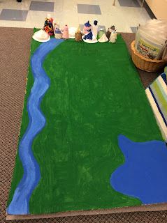
We had a great week! We finally started constructing the landforms for our community. Since collecting data about which landforms are most important in our community, we determined our community would have a river, a lake, and a mountain range. Then, students worked in groups to design blueprints for where the landforms should be within our community to provide the best possible quality of life. They considered factors such as access to transportation, safety (ie. landslides, floods), and wild animal habitats. Here are the blueprints made by each group:
Each group had the opportunity to present their ideas to the class about the location of their landforms. Next, we had a whole group discussion and decided on a layout for our community. We voted on all decisions that were made and decided to make it look like this:
You can see the mountains we built and added in the above picture! We also took turns painting the cardboard base. We decided to put our landforms on the outside, so we have lots of space when we are ready to start building our community, and to keep our community safe from potential natural disasters. To help with your understanding, our cardboard community is almost 6 feet tall, so this was a huge job that took most of the day yesterday!
We also had some students create some really tricky patterns today to quiz you at home! Here are some pattern cores, and they want to see if you can figure our what ATTRIBUTE is changing in the pattern? Hint: attributes that may be changing include: color, size, shape, direction, number of holes, etc.
A reminder that we are going on a walking field trip to Nickle Junior High School on Monday, December 3rd. The walk is about 60 minutes (30 mins each way) so please ensure your child is dressed appropriately for the long walk. We will only be going to Nickle for part of the morning and then it will be a regular day after we return.
Enjoy your weekend!
Lindsay Brown


No comments:
Post a Comment